What to know about a storm bringing high winds, heavy rain, snow to California and Pacific Northwest
SAN FRANCISCO (AP) — One of the strongest storms on the West Coast in decades knocked out power for thousands of people, unleashed strong winds that toppled trees and left two dead in Washington before making its way through Oregon to Northern California where on Thursday it dropped heavy snow and record amounts of rain.The National Weather Service extended a flood watch into Saturday for areas north of San Francisco as the region was inundated by the strongest atmospheric river — a long and wide plume of moisture that forms over an ocean and flows over land — so far this season. The storm system roared ashore Tuesday as a “bomb cyclone,” which occurs when a cyclone intensifies rapidly, and it's expected to bring moderate to heavy rain through Saturday, increasing the risk of flash flooding and rockslides, forecasters said.Here are some things to know about the storm:Strong winds bring power outages and topple treesHub peek embed (Weather) - Compressed layout (automatic embed) About 285,000 homes and businesses remain without power Thursday in Washington, where falling trees struck homes and littered roads across the western portion of the state, killing at least two people. One woman in Lynnwood died when a large tree fell on a homeless encampment, while another woman in Bellevue was killed when a tree fell on a home.Cities began opening warming centers offering free internet and device charging. In the hardest hit areas east of Seattle, power wasn’t expected to be fully restored until midday Saturday, Puget Sound Energy said.At least a dozen schools were closed in the Seattle area Wednesday and some opted to extend those closures through Thursday. In Enumclaw, east of Seattle, residents were cleaning up after their town clocked the highest winds in the state on Tuesday night: 74 mph (119 kph).Meanwhile, in Northern California, there were reports of power outages Thursday affecting more than 20,000 customers. Several districts in Sonoma County closed their schools Thursday due to the storm, county officials said.Officials warn of hazardous travel conditions About 150 flights were delayed and another two dozen were canceled Thursday at San Francisco International Airport, after hundreds were delayed and dozens were canceled on Wednesday, according to the flight tracking service FlightAware.Transportation officials shut down a 2-mile (3.2 kilometer) stretch of Northern California’s famed Avenue of the Giants, a scenic drive named for the towering coast redwoods along the route, due to flooding. The National Weather Service warned road travel conditions would be hazardous in the Sierra Nevada. “The hazardous conditions could impact the Friday evening and Monday morning commutes as roads become slick and snow covered,” the service said. “Gusty winds could bring down tree branches.”A winter storm watch was in place for the northern Sierra Nevada above 3,500 feet (1,100 meters), where 15 inches (38 cm) of snow was possible over two days. Wind gusts could top 75 mph (120 kph) in mountain areas, forecasters said.Maggie Eshbaugh, marketing manager at Sugar Bowl Resort, northwest of Lake Tahoe, said about a foot (30 centimeters) of snow fell there Wednesday night. She said they’re excited to welcome customers Friday, which is the earliest the ski resort has opened in 20 years. Interstate 5 was closed for an 11-mile (18-kilometer) stretch from Ashland, Oregon, to the California border on Wednesday morning due to extreme winter weather conditions in Northern California, according to the Oregon Department of Transportation. It was reopened by Wednesday night. The storm also caused some damage on State Highway 6 near Oregon's coast but it seemed to largely spare the state where no major damage was reported as of Thursday. Rain and snow could linger into next week A second, lighter wave of the storm is expected Saturday through Tuesday in Northern California, said meteorologist Courtney Carpenter, with the National Weather Service Sacramento. It will bring lighter rain in the lower elevations, but heavier mountain snow that will reach lower levels than the first wave, she said. Dangerous flash flooding, rockslides and debris flows were possible, especially where hillsides were loosened by recent wildfires, officials warned. Scott Rowe, a hydrologist with the weather service in Sacramento, said so far the ground has been able to absorb the rain in California’s Butte and Tehama counties where the Park Fire burned over the summer.“It’s not necessarily how much rain falls; it’s how fast the rain falls,” Rowe said Thursday.

SAN FRANCISCO (AP) — One of the strongest storms on the West Coast in decades knocked out power for thousands of people, unleashed strong winds that toppled trees and left two dead in Washington before making its way through Oregon to Northern California where on Thursday it dropped heavy snow and record amounts of rain.
The National Weather Service extended a flood watch into Saturday for areas north of San Francisco as the region was inundated by the strongest atmospheric river — a long and wide plume of moisture that forms over an ocean and flows over land — so far this season.
The storm system roared ashore Tuesday as a “bomb cyclone,” which occurs when a cyclone intensifies rapidly, and it's expected to bring moderate to heavy rain through Saturday, increasing the risk of flash flooding and rockslides, forecasters said.
Here are some things to know about the storm:
About 285,000 homes and businesses remain without power Thursday in Washington, where falling trees struck homes and littered roads across the western portion of the state, killing at least two people. One woman in Lynnwood died when a large tree fell on a homeless encampment, while another woman in Bellevue was killed when a tree fell on a home.
Cities began opening warming centers offering free internet and device charging. In the hardest hit areas east of Seattle, power wasn’t expected to be fully restored until midday Saturday, Puget Sound Energy said.
At least a dozen schools were closed in the Seattle area Wednesday and some opted to extend those closures through Thursday. In Enumclaw, east of Seattle, residents were cleaning up after their town clocked the highest winds in the state on Tuesday night: 74 mph (119 kph).
Meanwhile, in Northern California, there were reports of power outages Thursday affecting more than 20,000 customers. Several districts in Sonoma County closed their schools Thursday due to the storm, county officials said.
About 150 flights were delayed and another two dozen were canceled Thursday at San Francisco International Airport, after hundreds were delayed and dozens were canceled on Wednesday, according to the flight tracking service FlightAware.
Transportation officials shut down a 2-mile (3.2 kilometer) stretch of Northern California’s famed Avenue of the Giants, a scenic drive named for the towering coast redwoods along the route, due to flooding. The National Weather Service warned road travel conditions would be hazardous in the Sierra Nevada.
“The hazardous conditions could impact the Friday evening and Monday morning commutes as roads become slick and snow covered,” the service said. “Gusty winds could bring down tree branches.”
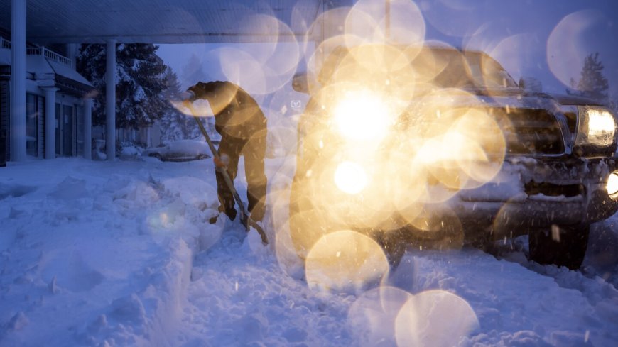
A winter storm watch was in place for the northern Sierra Nevada above 3,500 feet (1,100 meters), where 15 inches (38 cm) of snow was possible over two days. Wind gusts could top 75 mph (120 kph) in mountain areas, forecasters said.
Maggie Eshbaugh, marketing manager at Sugar Bowl Resort, northwest of Lake Tahoe, said about a foot (30 centimeters) of snow fell there Wednesday night. She said they’re excited to welcome customers Friday, which is the earliest the ski resort has opened in 20 years.
Interstate 5 was closed for an 11-mile (18-kilometer) stretch from Ashland, Oregon, to the California border on Wednesday morning due to extreme winter weather conditions in Northern California, according to the Oregon Department of Transportation. It was reopened by Wednesday night.
The storm also caused some damage on State Highway 6 near Oregon's coast but it seemed to largely spare the state where no major damage was reported as of Thursday.
A second, lighter wave of the storm is expected Saturday through Tuesday in Northern California, said meteorologist Courtney Carpenter, with the National Weather Service Sacramento. It will bring lighter rain in the lower elevations, but heavier mountain snow that will reach lower levels than the first wave, she said.
Dangerous flash flooding, rockslides and debris flows were possible, especially where hillsides were loosened by recent wildfires, officials warned. Scott Rowe, a hydrologist with the weather service in Sacramento, said so far the ground has been able to absorb the rain in California’s Butte and Tehama counties where the Park Fire burned over the summer.
“It’s not necessarily how much rain falls; it’s how fast the rain falls,” Rowe said Thursday.


